Radar is not available in most ocean regions which can make monitoring hurricane intensity challenging prior to landfall. LENS solves that problem using mesoscale satellite data to synthesize radar to enhance spatial and temporal coverage of tropical storms at crucial times.
Mesoscale imagery from geostationary satellites, such as GOES-16/18, are capable of observing extreme weather events at a 30 second to 1 minute temporal resolution, providing near continuous video like data. The capability allows scientists to “point” mesoscale mode to user defined 1000 km x 1000 km regions of interest.
Meteorologists use the mesoscale data feed to visually analyze the development of events such as tropical cyclone intensification or wildfire spread. However, beyond visualization purposes, the data is rarely used for modeling and downstream applications due to the high-resolution and reduced regional coverage. In fact, ERA5 operational data assimilation is only capable of partially ingesting geostationary imagery at coarsened spatial and temporal resolutions.
Zeus AI’s LENS system is capable of ingesting 1-minute mesoscale imagery to generate nearly continuous meteorological variables like wind speed, cloud cover, temperature, and radar reflectively. Moreover, LENS is capable of ingesting mesoscale data in real-time enabling up to the minute data during the most extreme weather events.
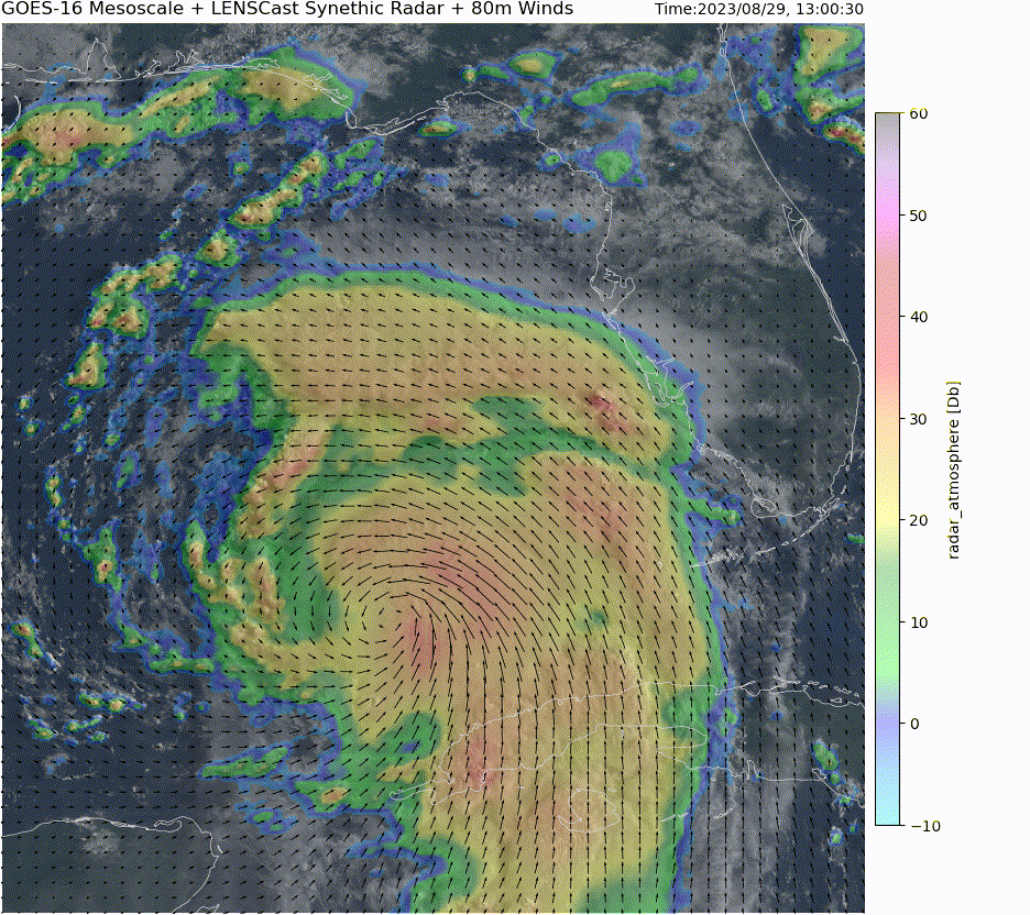
LENS applied to mesoscale imagery of Hurricane Idalia can be seen in the figure above. In this sequence, we overlay Zeus AI’s LENS synthetic radar and winds data on true color imagery from the satellite. We find that both the radar and winds are highly consistent across time and space, lining up well with the satellite images.
As we see in the figure above, LENS synthetic radar corresponds the structure from tropical cyclones with heavy rain bands near the eye and a clear outer boundary. We also plot directional vectors of 80 meter winds to show the storms motion. The eye of the storm is clearly captured with strong surrounding rotational movement. At the time of the observations, the vectors show northern movement overall. Wind shear is also seen in the true color imagery where upper level clouds (top right) move in the opposite direction of winds near the surface.
The computational efficiency gained from AI weather technology is especially highlighted at mesoscale resolutions where traditional assimilation systems fail. If your team is interested in mesoscale weather fields, please reach out at hello@myzeus.ai.