Zeus AI is pleased to announce the release of LENS-Cast, a new weather nowcasting product, offering near real-time processing and continuous temporal resolution. LENS is our proprietary Low-latency Environmental Prediction from Neural Systems that uses generative modeling to assimilate satellite observations with coarse resolution weather models at a fraction of the time compared with operational data assimilation systems. Leveraging global geostationary satellites, LENS-Analysis produces meterological analysis data of numerous variables, including winds, temperature, solar irradiance, radar, and more, at a 2 km spatial resolution and 5-15 minute temporal resolution. LENS-Cast is a neural operator trained on our proprietary analysis data that produces temporally continuous forecasts. This technology generates forecasts for a suite of weather variables faster and at higher resolutions than other models in the market.
Machine learning has quickly become a relevant method for weather forecasting across scales, from nowcasts to decadal climate scale projections. It has been found that pure AI forecasting methods require less computational resources, are significantly faster, and more accurate than traditional forecasts. However, current AI forecasting approaches are dependent on the initial conditions generated from data assimilation. We have seen numerous companies enter the market based on improved forecasts dependent on traditional data assimilation. Zeus AI believes machine learning can also be used to emulate data assimilation at high resolutions and fast refresh rates providing more timely forecast information. Though ML has been widely applied to nowcasting radar imagery, to our knowledge none have produced multi-variate initial conditions and forecasts.
The highest quality, highest resolution meteorological dataset produced by NOAA is the High-Resolution Rapid Refresh model (HRRR). HRRR is refreshed once per hour and takes approximately 1.5 hours to produce an initial condition and another hour to complete the forecast. HRRR uses RAP/GFS as boundary conditions, ingesting radar and satellite data into a convection allowing model. LENS leverages the highly accurate analysis data produced by HRRR to train our satellite based initial condition generative model from real-time remotely sensed data and coarse forecasts. This approach effectively emulates all HRRR variables where geostationary data is available (global minus high latitudes).
The methodology underlying LENS will enable Zeus AI to gradually improve our systems with longer forecast horizons, higher accuracy, and expanded spatial coverage. At this time, we are releasing a 6-hour nowcast covering North America with a total of 19 variables. Variables include air and surface temperature, solar irradiances, 10m and 80m winds, relative humidity, dew point, cloud cover, surface pressure, precipitation rate, and radar reflectivity. LENS-Cast is refreshed every 15-minutes, providing users with the most up to date weather data available.
Summary of LENS-Cast features
- Faster forecast updates: Our data-driven weather model generates forecasts more quickly than traditional models that take hours to run on high-performance computing clusters, allowing more frequent updates and lower latency.
- Improved accuracy: Refreshing models more frequently can improve accuracy for high-impact weather events, such as severe storms or hurricanes, where small changes in the forecast can have significant impacts on people’s lives and property.
- Expanded data assimilation: Our AI system assimilates terabytes of geostationary satellite data per day, only a fraction of which is used in traditional forecasting due to longstanding computational limitations.
- Continuous improvement: The rapidity of our model—running in less than 5 minutes on one GPU—enables rapid technological development and improvement.
Some analysis
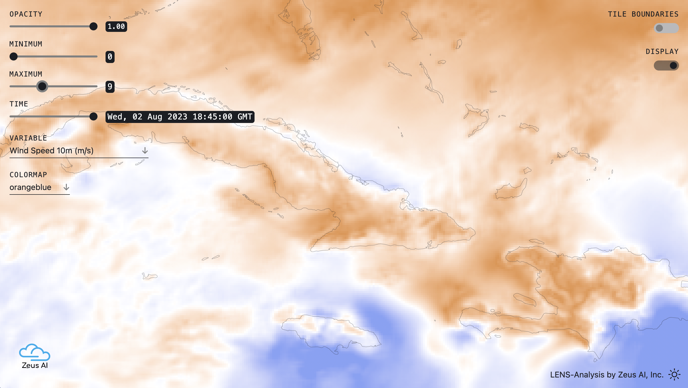
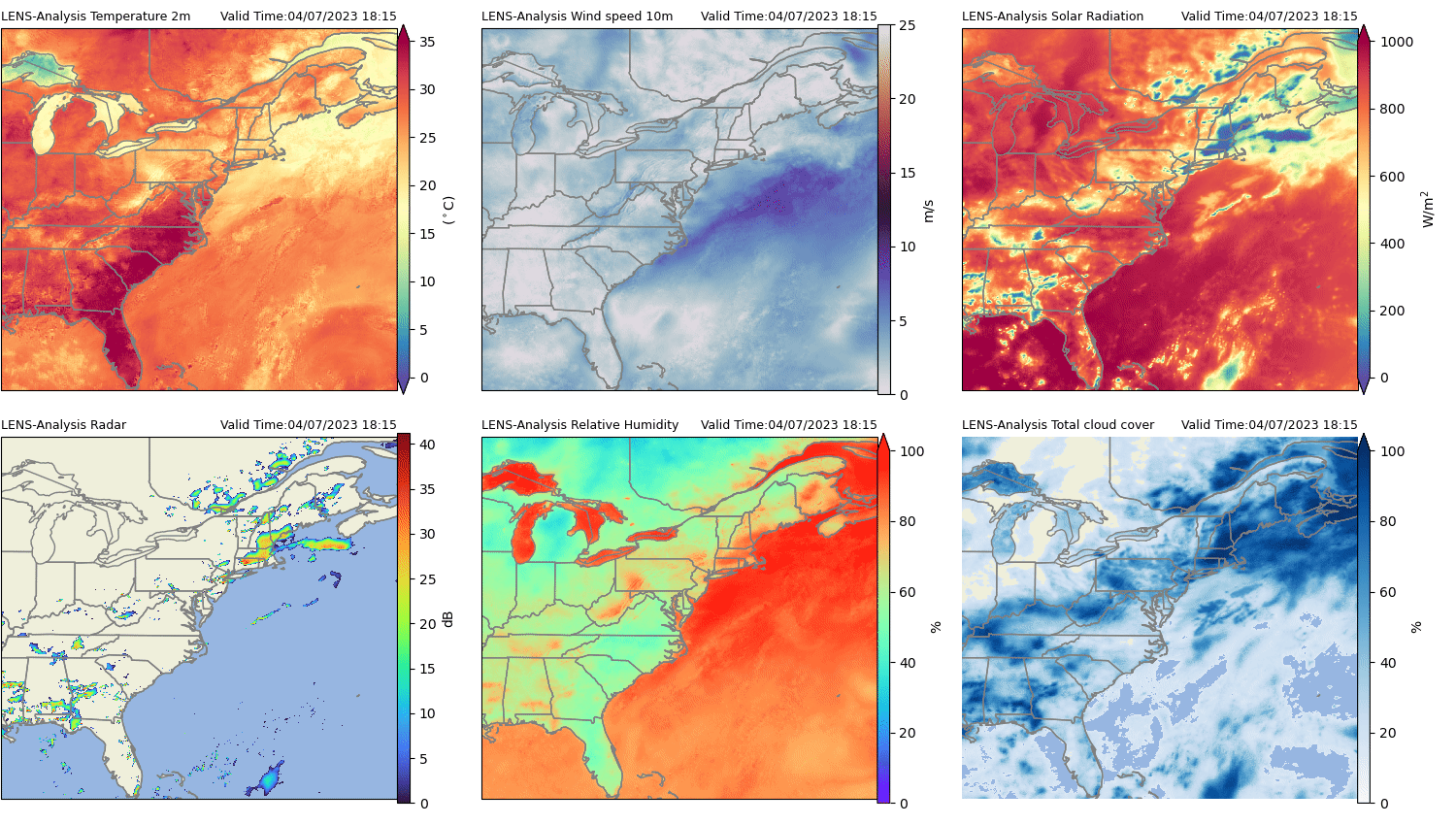
Evaluating a new weather product requires analysis in multiple dimensions and across different ground truth observations. As we are producing our own initial conditions, it is first critical to show that LENS-Analysis provides accuracy against ground truth station measurement and spatio-temporal consistency across frames. In the figure below, we show a sequence of frames at a 15-minute frequency for 6 variables including temperature, wind speed, solar radiation, radar, humidity, and cloud cover that highlights the consistency. We see that LENS-Analysis Radar captures the development and movement of precipitation events and corresponds well with cloud cover. This capability presents an important alternative in regions without ground based radar systems.
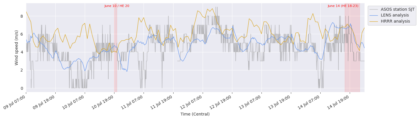
We compare our model’s wind speed at 10m versus NOAA’s HRRR with ground truth station observations from the ASOS network, providing surface level measurements at major airports. It is noted that HRRR assimilates ASOS stations while LENS does not. Below we show a time-series of LENS-Analysis for 5-days in July compared with HRRR and ASOS. It is shown that LENS and HRRR capture the inter-day variability with similar errors around the station observation. It is seen that HRRR completely misses a low-wind speed event while LENS captures it well.
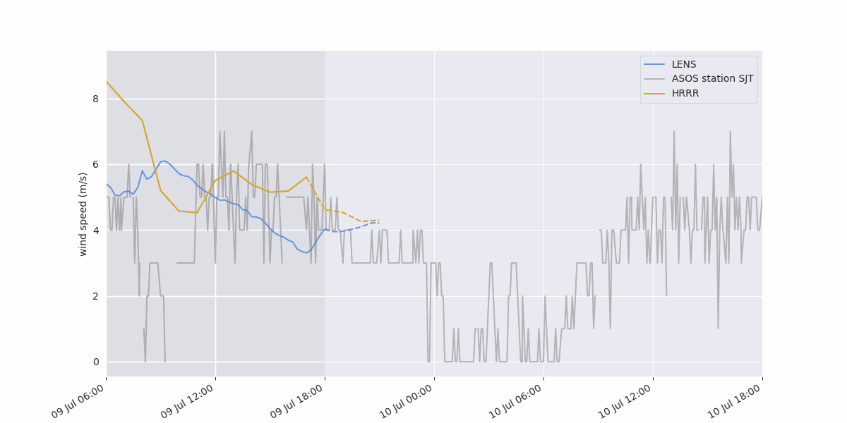
The following animation compares the 3-hour forecasts of LENS-Cast vs HRRR and their update frequencies. We see that LENS-Cast produces 4x the number forecasts compared to HRRRR while being 1.5 hours ahead. We also find similar results shown in the analysis where LENS-Analysis is capable of forecasting intra-day events.
These initial results show promise in LENS ability to efficiently produce initial conditions in a near-realtime basis and competitive with HRRR. In the coming months we will present more analysis and evaluation of our data products, including the numerous variables not covered in this initial description. We look forward to sharing our developments as we begin ingesting more datasets and forecasting at further lead times.
Conclusion
At Zeus AI we are committed to developing innovative solutions that help individuals, businesses, and communities adapt to changing weather patterns and reduce their impact on the environment. We invite users to try our new weather forecast and experience the benefits of faster processing times, continuous updates, and geostationary satellite data assimilation firsthand. If you’d like to stay in touch, please subscribe to our upcoming newsletter to stay up to date.